When we arrived at Smokemont Campground, we looked for the D loop where the hiker parking was supposed to be. The gate to the back loops of the campground was locked, so we had to park closer to the front instead. Only one of the restrooms was open--the one closest to the front of the campground, but that was way better than having to drive several miles out to a store as we have done on previous hikes.
 |
| Socks make pretty good gloves in a pinch |
We took the advice of the author of the Hiking Trails of the Smokies and started our 5.6 mile loop on the Bradley Fork Trail which runs along one of the most picturesque rivers in the Park. I kept scanning the runs and deep holes for any sign of Brookies, but without my polarized sunglasses, I couldn't spot them even though I know they must have been there. Bradley Fork Trail is a slow ascent on a road bed, part of which is a section of the Benton MacKaye Trail, a 300 mile trail named for one of the men who first envisioned the Appalachian Trail. The Benton MacKaye runs from Big Creek (in the Smokies--not too far from where we were) to Springer Mountain, Georgia, sharing the Southern Terminus with the AT. The short section that we were on was very pleasant, with a gradual grade and the musical rippling of the waters of the Bradley Fork of the Oconaluftee River here at Smokemont. The entire length of the Bradley Fork Trail that we were on until it reached the Smokemont Trail was one of the most beautiful trails we have ever done. We resolved that we would return and bring some of our group members that don't like to do the longer hikes but enjoy a nice, peaceful day in the Park. It is definitely worth the drive.
After about 1.7 miles on the Bradley Fork Trail, we came to the intersection of the Smokemont Loop Trail. Just as the Loop trail headed off to the left, it went down a hill on beautifully constructed steps to one of the longest footlogs in the Smokies. This footlog is narrow and long, but plenty sturdy and you simply must stop in the middle to enjoy the view of this beautiful stream. Once the trail crosses the river, it becomes a single-file trail strewn with leaves and climbing up and around the hills. This steady climb goes on for about 1.75 miles and requires several stops to keep your heart from beating in your ears, but it is a pleasant climb. The trail is well-maintained, showing none of the erosion that other similar trails we've traversed recently have shown. Much of the trail is surrounded by gorgeous rhododendron thickets and tunnels or clearings that overlook nearby peaks .
After topping out at not quite two miles in, the downhill began, not quite as steep as the ascent, but a little longer, hence the recommendation in the Hiking Trail book to do the Bradley Fork Trail first.
 |
| Typical section of the Smokemont Loop Trail |
Fairly close to the end of this loop, we encountered a large tree which had fallen over the trail. The youngest member of our party, almost 20 years younger than me, went under the large trunk which blocked our path. Jennifer and I decided we would climb over it. This proved to be a comical moment when she got stuck astride this huge log, unable to move in either direction with feet way off the ground. We laughed till we cried and then helped her make it over.
 |
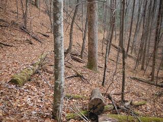
| The ridge where the bear had been |
This 5.6 mile loop hike was just exactly what I needed to help deal with all the stressors from work during this hectic week. Who needs Xanax when you've got the most beautiful place in the world right up the road? Now, if I could only figure out how to hike, oh, somewhere around Wednesday, I think it would make the work week much more bearable!


No comments:
Post a Comment