Showing posts with label Mt. LeConte. Show all posts

Wednesday, October 17, 2012

Mt. LeConte Shared and Magnified!

On Wednesday of this past week, I took probably my favorite trip to the summit of Mt. LeConte because I shared that experience with 25 teenagers, many of whom had never hiked at all. LeConte has been one of my favorite spots on Earth for a year and a half now, since I first hiked to the top in May of 2011 via Alum Cave Bluff Trail. I went again this spring with a larger group of ladies this time via the Boulevard Trail. On the first trip, the weather was perfect with crystal clear blue skies and visibility that stretched literally for miles. The second trip was less stellar for a couple of reasons, but was enjoyable nonetheless. This trip, however, I do believe was my very favorite because I shared this special place with my students.

We loaded the bus at 5:30 a.m. in the parking lot of our high school. Believe me, that's early for 16 and 17 year olds! They complained of having to get up so early, but I noticed they were smiling and even a little giddy with excitement. Armed with pillows and blankets in addition to their hiking gear, the kids piled on the bus and promptly went to sleep. We arrived at Sugarlands Nature Center for our final "real" bathroom break a little before 7:00 a.m. At that time, I also divvied up the supplies that I had brought for all of them. I've already mentioned in a previous post that Blue Ridge Mountain Sports in Knoxville, TN donated 44 Clif Bars for the students. Our local Food City donated bananas for everyone to have during a break on the trail. I always find that bananas can give me that little extra shot of energy when I begin to drag a bit. Also, Earth Fare provided 48 bottles of water for us to distribute to the kids. Most of them did not have a water bladder for their packs and I wanted to be sure they carried enough water with them to the top. These supplies were greatly appreciated and made for a much more enjoyable hike for these students.

Once I distributed the supplies and handed out homemade blueberry and/or pumpkin muffins made by a fellow teacher and one of the chaperones as one last bit of nourishment, the bus took us our last little distance up to the trailhead. I was simply thrilled to be ready to head up the trail just after daylight at approximately 7:30 a.m. The kids were so cute getting all their gear on. We talked about expected behaviors and trail etiquette, and then we embarked on what would be an almost perfect day.

The morning was brisk, and most everyone started out in fuzzy fleece jackets, sweatshirts, or even heavier coats. After about a mile it was time for a stop to shed some layers. We were definitely warming up, making gloves and jackets unnecessary. I was really surprised at how quickly we arrived at Arch Rock. We were making good time, but this hike was never supposed to be about speed. I loved overhearing the kids when we would come to a river crossing. They didn't quite know what to think about those footbridges made of a log and one handrail. They crossed tentatively and nervously, but they crossed! At one point along the trail, one student said, "What's that smell?" One of the other chaperones replied, "Nature!" I got a little thrill knowing that this student had never been in the Smokies before and that all of this wonderful natural world that I take for granted was a totally new experience for her. Numerous times that day, students would remark about something beautiful or unexpected and my heart did little flips. It made the 5-mile walk up there almost effortless. The students did a great job. Even though I was in the back with the group of girls who were the slowest hikers, they did not complain. They got tired, and I let them take lots of breaks, but when I told them we needed to get moving again (because we were getting cold), they got up and hit the trail again. They didn't ask me how much further more than maybe 20-30 times. :)

As long as we kept hiking, our temperature was fine even though you could tell it was getting much colder as we gained in elevation. At about 9:00 a.m. we stopped to regroup at Alum Cave Bluff and take a snack break. I wanted to be sure the students stopped long enough to get some good nourishment (the bananas and Clif Bars) and drink plenty of water. If you know teenagers, you know how they will cave in to peer pressure--even the peer pressure to walk faster than they need to without taking breaks. This rest and refuel break was mandatory and it was good to get to see everyone in the group together and assess our condition at the half way point. It appeared that everyone was still in good spirits and most were ready to finish the deed soon after stopping to rest. We didn't stay too long because we were beginning to get cool again, and we were soon making the climb along the rock walls where cables bolted into the mountain walls provided my students with handholds and me with peace of mind.

We had gotten some great photo ops on the cliffs just before the Bluff, but shortly after leaving the Bluff, we ascended literally into the clouds and that's where we remained for the rest of the day. It never did rain on us, but my hair sure looked and felt like it had. It was soaking wet from the condensation within the clouds. I was disappointed that the views were obscured, but the girls in my group were fascinated with the fact that they were INSIDE a cloud!

The mile and a half or so above Alum Cave Bluff is the most difficult part of the hike and some of these kids were struggling a bit at this point. I never really worried about them not being able to make it, and they still weren't complaining. But the breaks became more frequent and once one of them complained of being lightheaded. After another break, this time with some more food and water, she felt better and we continued on. Soon we arrived at the point in the trail where the ecosystem changes dramatically and you just know you are nearing the top. Many of my students said that last part of the forest right before you get to the lodge area was their favorite part of the whole trip.

I have a feeling though, that for most of them, the favorite part was the lodge itself where they could sit by the fire, rest, and drink some of the most delicious hot chocolate found anywhere on the planet! That $3 is the best money I've ever spent, even the third time around! While we were resting and relishing the fact that yes, we had indeed climbed Mt. LeConte, we were met by Tim Line, the man who runs the LeConte Lodge. He had agreed to talk with my students about the precautions that the lodge and the Park Service are taking in light of the hantavirus outbreak in Yosemite, which was (at least in part) the reason we had made this trek. We moved into the "office" area where the shirts are sold. My kids gathered around the fireplace in the center of the room while Tim told us all about the deer mice that are a part of the LeConte experience and what his staff and the Park Service are doing to keep visitors safe. There has never been a case of hantavirus in the Smokies; apparently this is attributed to the moist and humid environment in our area as compared to the dry region in and around Yosemite. This humidity keeps the feces and urine particles from becoming airborne which is how they are transferred to humans. We were also joined by a Park Ranger who apparently made his way up to LeConte just because he knew we were coming to learn about the risks and preventions of hantavirus in the Smokies. He, too, did a marvelous job explaining the Park Service's position and policies relevant to hantavirus here in our own backyard. Both of these gentlemen gave my students plenty to think about and investigate further. They also treated the kids respectfully and took their questions seriously. We also received an email the next day expressing interest in any findings or proposals the students may develop as a result of their investigations and research. After meeting with these two gentlemen, we made our way up the trail a quarter mile or so to the LeConte Shelter so the kids could see what a backcountry shelter looks like considering that they, too, are visited regularly by the deer mice that may be infected by the hantavirus.
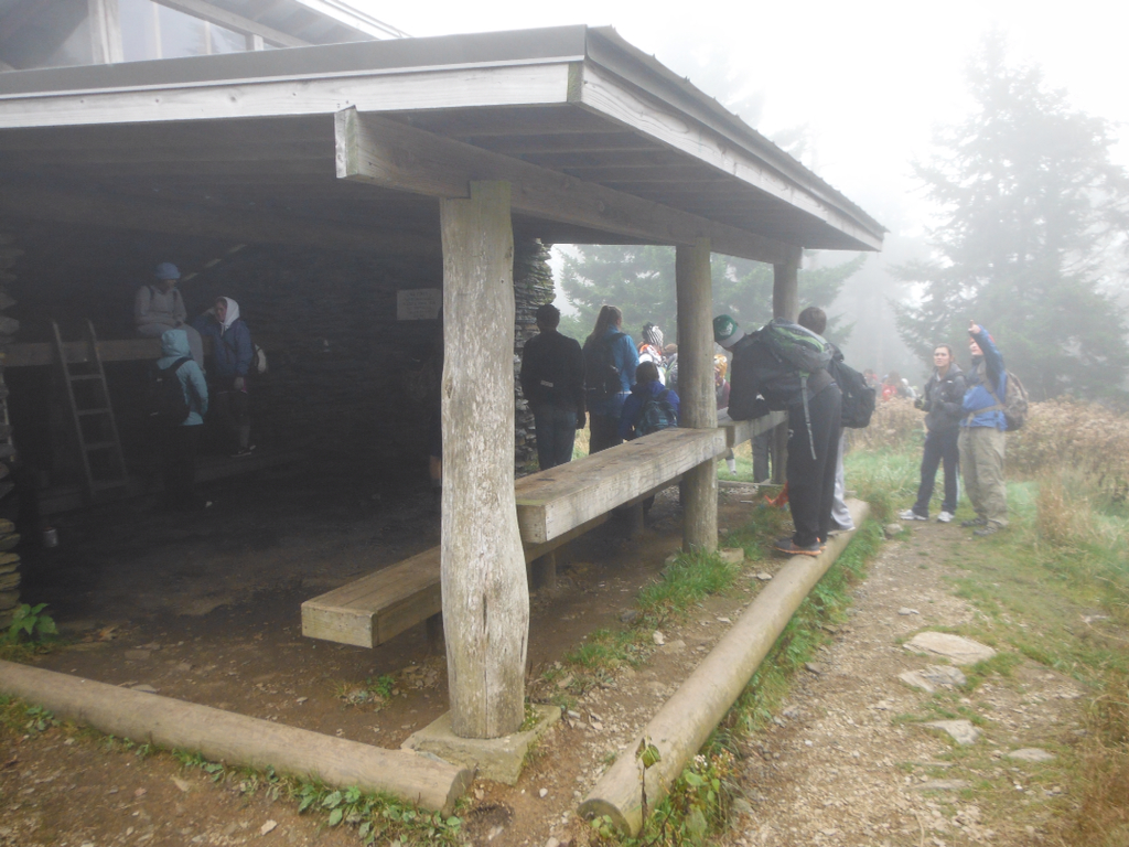
These students will continue to work on the scientific research behind our trip to the summit of Mt. LeConte in the coming month, and will put together presentations and proposals to share with the Park Service and perhaps the Friends of the Smokies, but I, and hopefully they, will forever cherish our time on the mountain. I know that this mountain will always hold a special place in my heart because of this experience. Someone once said, "Joy shared is joy magnified." The same thing definitely holds true for this magical mountain.


Tuesday, September 18, 2012

Call me crazy! Field trip to Mt. LeConte!

I may have totally lost my mind, but I just received word that my field trip request to take my Microbiology classes to the summit of Mt. LeConte has been approved! What that means is that I will be taking approximately 35 high school students on a 10-mile hike up and back on Alum Cave Bluff trail.

I am so proud of these students. I asked them to do some research on current events in the field of microbiology and several of them began discussing the emergence of the hantavirus out of Yosemite National Park and what a scary scenario that is. Hantavirus is carried by rats and mice; humans are exposed to the virus by breathing in dried feces or urine particles that are in the air in rodent-infested shelters and cabins in Yosemite. According to what I have read recently, this disease is lethal approximately 40% of the time, and survivors may suffer debilitating symptoms long after they have "recovered." My students began making the connection between the rat/mouse infestations in Yosemite Park shelters and cabins with conditions in the part of the Smokies with which some of them are familiar. They wondered if a rodent control program is in place in the LeConte cabins as well as in the shelters along the Appalachian Trail in Tennessee.

My students quickly decided that, as a part of our course work in Microbiology, they wanted to think like epidemiologists and investigate the conditions in Yosemite which have allowed the hantavirus to become such a problem and look at ways to prevent similar conditions from developing right in our own park. From that arose the idea that we would actually visit Mt. LeConte to gather information for their project. While we are up there, I hope to be able to get LeConte Lodge employees to meet with my students and provide some insight to whatever programs are in place relevant to rodent control or explain to my students the impediments that prevent such programs. I truly hope that park or lodge employees will appreciate the real-world relevance that such a project provides for these students and will honor my request.

What else does that mean? It means that I will be able to expose these students to the grandeur and beauty of one of my favorite places on earth. Mt. LeConte is special in many ways. The challenge of the hike up will encourage these kids to get in shape to the best of their ability between now and the day of our hike. The accomplishment they feel when they reach the summit will stay with them forever, as will the views they will experience if we are blessed with good weather at the top. It also means that many of these kids who have never even been to the Smokies, although they are practically in our backyard, will get to take what could turn out to be the trip of a lifetime!

I will be looking for some corporate sponsors to help us purchase things like Clif Bars, bananas, and water bottles. I'll also be looking for a company to provide breakfast biscuits and juice or milk for us to eat on the bus ride up to the trail head. In addition, I would LOVE for someone to donate enough money to purchase each student one of the "I Hiked It" shirts available at the LeConte Lodge store!  I'll let you know who steps up and helps us out with this. The transportation and other expenses are more expensive than I thought they would be when I first considered the idea. If you have any ideas, please feel free to share them with me as I try to arrange a trip these kids can afford and will enjoy. Also, if you don't mind, pray or hope for great weather for us! :)


Monday, May 14, 2012

Mt. LeConte--Second Time Around--Up, Up in the Clouds!

Cloud cover began to clear as we were coming down Alum Cave Bluff Trail

Early on Saturday morning, my hiking group began our second trip up to Mt. LeConte.  This time we began at Newfound Gap, stepping out on the Appalachian Trail, walking literally along the Tennessee/North Carolina border under low cloud cover.  Some of my companions had never been on the AT before, so they learned first-hand the mystique of the white blazes.  They also learned that the AT is a little different than most of the trails we have been on in the Smoky Mountains--a little more challenging. The thing I love the most about the AT is that much of the part that I've covered tracks along the ridges.  I love to be walking along those ridges with nothing but "down" on either side!  Even though we were only on the AT for 2.7 miles, there was enough ridge-walking to give my hiking buddies a little bit of the feel that I cherish.


The views from those ridges on Saturday, though, were severely limited due to the low cloud cover.  In fact, once we reached the Boulevard Trail and quickly covered the next .3 miles, we found ourselves at the turning point to go to the Jump Off but decided to save that side trip for another day.  There just wasn't going to be anything to see.  It made me sad, but it was probably a good thing after all.


Loose rocks "pave" much of the Boulevard Trail
The Boulevard Trail was deceptively mild at the beginning, except for the loose rocks that lined much of the trail.  The trail began as primarily a descent, but soon began a fairly mild climb toward the back side of Mt. LeConte.  We were passed by a couple of older men who had apparently hiked LeConte numerous times.  One of them told us Boulevard was his favorite way to the top; we were appropriately encouraged.


We continued to make our way up and around the mountain and the clouds continued to restrict our view.  There were many places along the way where I would step over to what should have been exquisite views of the valleys below only to see nothing but clouds and fog.  I think that's part of what made the hike begin to be more difficult as we began to tire.  I remember on our previous trip, the views were so spectacular that they were energizing in and of themselves!  We got no such encouragement as we made our way higher and higher up on the slopes of LeConte on this day. 


I simply wasn't prepared for the difficulty of the last mile or mile and a half of this trail.  The guidebooks that I use gave no warning, so I'm thinking it must have been the combination of the loose rocky footing, the additional length of the trail compared to Alum Cave Bluffs trail we traveled last year, and my lack of serious conditioning.  I remember thinking we were probably getting very close to the top as we were seeing many skeletons of hemlock trees on the nearby slopes.  It just seemed like we were almost to the top.  Then, suddenly we rounded one bend in the trail, looked ahead and saw a tremendous incline above us--a slope we knew we still had to climb.  My spirits tumbled and from there as the footing deteriorated, so did my spirits.  I'm thankful that I knew it was a shorter distance to the bottom if I just kept going than it would have been if I had turned around.  I don't think I would have given up and turned around, but I might have been tempted.  From there on, it was an act of sheer will to keep going.  We were more than tired.  We joked about putting one foot in front of the other and don't look up!

Part of that last, grueling mile.  Doesn't seem very steep, but we were really tired!
This picture shows the area of the mountain where one face of the slope simply slid down into the valley after a deluge many years ago.  It left more loose rock and unsure footing for us with what should have been an excellent view opportunity had it not been for the clouds.  We pressed on.  Finally, we reached the turn off to Myrtle Point.  The mountain was still shrouded in dense clouds, and tired as we were, we decided not to even go the .2 miles it would have taken for us to experience Myrtle Point.  Had we not been socked in, we would have gone no matter how tired we were.  Somewhat discouraged, we continued on after a short rest.


We made it to High Top!

Our first point of rejuvenation occurred when we made it to High Top.  We knew that this little pile of rocks was the attempt by hikers to make Mt. LeConte higher than Clingman's Dome. It shows the love that hikers have for Mt. LeConte--the determination that this difficult to reach summit should outshine the slightly higher summit of Clingman's Dome with its paved path that presents no challenge for the typical hiking enthusiast.  We began to smile again in appreciation of that fact and because, honestly, the trail could ONLY go down from here--something we were ready for!  With renewed spirits and a burst of energy, we began the short trek to LeConte Lodge from High Top.


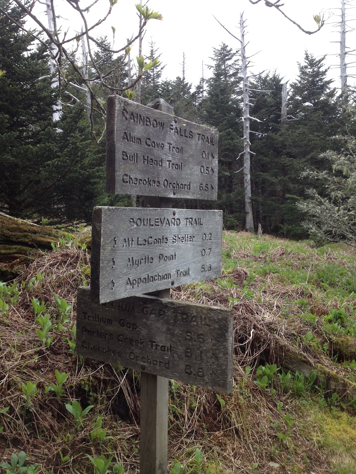
Soon, we encountered the trail intersection where the Rainbow Falls Trail, the Boulevard Trail, and Trillium Gap trail come together.  A solo hiker we had befriended at High Top told us that this is one of only 13 places in the park where three trails come together.  I'm not sure how accurate his information was, but it sounded pretty cool at the time.

Within just a few short minutes now, we finally saw the cabins that populate the area around Mt. LeConte Lodge, a welcome sight to say the least.  We had done it!  We had made what had proven to be a more difficult journey than had been expected and had beaten back discouragement and disappointment to press on until we had achieved our goal.  Exhausted, but encouraged, we made our way into the dining room where we had reservations for lunch.  Lunch consisted of vegetable soup and a chicken salad sandwich on homemade bread.  The best part, according to my hiking buddies who inhaled theirs, was the cow paddy cookie!  I don't know--I was really too tired to eat.  To me, though, I'd have paid the $9.00 for just the hot chocolate!  It was fabulous and helped beat back some of the cold that had chilled my hands on the way up.


Again, we decided not to hike out to Cliff Tops where I had taken such awe-inspiring pictures last year.  We rested for our hike down.  We had taken longer than expected to climb LeConte--a solid 5 hours, so we were feeling a little rushed to get off the mountain by dark.  However, we did take time to purchase our "I HIKED IT" shirts in the office before we left.  Thankfully, though, just as we were preparing to leave, the clouds began to part and I was able to get a few nice shots.

The beginning of clearing skies--better late than never!

Our descent was via Alum Cave Bluffs Trail.  Even with a companion who had hurt her knee near the top, we made the hike down in less than four hours and about an hour before dark.  We will hike Mt. LeConte again, but I'm going to really work on conditioning between now and then.  Even hiking 10-12 miles every other weekend had not prepared me for this hike.  We are tentatively planning on doing it again in the fall, hopefully on a day where the colors are vibrant and the skies are clear.  There's just something about that mountain!  As much as I felt it had beaten me on Saturday, I am drawn to ascend it once again.

Wednesday, May 9, 2012

Preparing for Mt. LeConte--3 Days and Counting!

Trying to actually work instead of thinking about Mt. LeConte has become a real challenge.  I would much rather be planning the hike instead of doing what I probably should be doing right now, which is grading papers.  So, I'm taking a few minutes break to make my paper grading more productive later, right?

It is time to call the Lodge at Mt. LeConte to order our lunches for the hike.  I know $9.00 sounds like a lot for lunch, but when you think about everything it takes to get the food up to the summit of LeConte, at over 6500 feet elevation, I'm not the least bit worried about it.  In fact, the idea that our lunch supplies will have been carried by llama up the mountain is a bit intriguing.  The weather is predicted to cooperate, so I will make that call in a few minutes.

Our group continues to grow.  We are up to approximately 10 people at the moment, and I won't be surprised if others decide to join us last minute.  We are pretty excited and folks are definitely talking about the trip, so that may entice others to come with us.  The more the merrier!

Chota GVX 2 Ultralight Pullover
I do look at this hike a little differently than some earlier hikes at lower, more predictable elevations.  Although the weather in Gatlinburg, TN is predicted to be clear with a high of 77 on Saturday, the high on LeConte typically runs about 10 degrees cooler than that of Gatlinburg.  That puts our predicted high at around 67.  Because of the extreme elevation changes and how early we must start, this hike will probably begin in temps that are quite cold and require either layers or a jacket.  I will be hiking in no cotton, as usual, just in case showers blow up and get us wet, which is always possible when you hike in the Smokies!  I've just bought a new lightweight windbreaker that is also waterproof, made by Chota primarily for the fly-fishing market, that I will definitely take with me on this hike.  It weighs only 6 ounces and will serve as a nice light jacket and also excellent protection in the event of rain.  I purchased it a few weeks ago at Little River Outfitters in Townsend, and it has already kept me totally dry in a downpour on one fishing outing.  If, however, we do get wet, as long as you are wearing the great new dri-fit fabrics, you dry out very quickly and rain shouldn't be a problem.  I'm just so very glad there are no storms forecast for Saturday. One thing that I'm not crazy about is hiking at high elevations in storms.  I don't mind it if you are above the storm clouds, but being caught in a thunderstorm with no shelter is probably my least favorite thing about hiking.  Hopefully the forecast will hold and the weather will stay clear.

Gear that I will use on this hike includes my trusty Keen Targhee II boots which provide enough ankle support for me that I don't worry about turning my ankle if the trail gets rocky.  I absolutely love these boots!  I also paid the extra money to buy Keen socks and find that the built in arch support works great for me.  This built in arch support requires the socks to be fitted for left and right feet which some hikers find annoying, but I love them! I will hike in zippered hiking pants and will probably start off with the legs on, but I bet I shed then before reaching the top.  I'm not sure which of my dri-fit shirts I will don on this day, perhaps the I Hiked LeConte in 2011 shirt I bought at the top last year.  I will carry a simple day pack that I purchased at Walmart a couple years ago.  It has served me well, and I saved a little money there.  It does have nicely padded straps which I think are very important and the waist belt has padding and supply pockets.

For food, I will take a couple of Clif Bars with me.  I really like the Blueberry Crisp and the Macadamia Nut flavors, personally.  I usually also carry some beef jerky with me on long hikes.  I don't know if it's the protein or the salt, but it does a good job reinvigorating me when I have a "sinking spell" as my grandmother would say.  My day pack has a water bladder, and I will also carry my MSR Miniworks water pump.  I doubt I will need it because there is fresh water at the top of the mountain with which I can refill my water container, but I've wished for it on the last two hikes and it doesn't weigh all that much, so it's going with me.  I will also make sure I take a flashlight with me on this hike because of the distance.  I think we will have plenty of time to hike up and back before dark, but just in case of an emergency or if someone needs more time coming down, I'll have one with me. Then, of course, we will take the normal supplies with us--first aid kit, snake bite kit, Benadryl, etc.  One of the most important things we will carry with us though is the Ibuprofen!  At our age, a hike of this length makes us SORE!  We will take a couple of these somewhere on the way down, so that after we have sat in the car an hour or so we will actually be able to get OUT of the car! Last spring, after our first LeConte hike, the hardest thing we did all day was pour ourselves out of the truck when we got home. So, as I look forward to the weekend, I'm so excited. I can hardly stand the wait until Saturday. But in the meantime, guess I'd better get back to grading those papers.  :)

Thursday, May 3, 2012

Planning for Mt. LeConte

View from Mt. LeConte Summit Store


In less than two weeks a group of friends and co-workers is going to hike to the top of Mt. LeConte in the Great Smoky Mountains National Park.  Three of us went last year and you can find a blog about that hike earlier in the entries on this site.  This year, we want a little more challenge so we are taking a longer route.  Last year's hike was 10 miles round trip.  This year we will begin on the Appalachian Trail at Newfound Gap and hike up to the Boulevard Trail and take it to the summit of LeConte.  That is about 8.1 miles on the first leg of our journey.  A few of us will also add another 1.4 miles by taking two spurs--the first is the Jumpoff that leaves Boulevard trail to go to a rock outcropping that overlooks Charlie's Bunion, and the second is the short jaunt off the trail to Myrtle's Point on Mt. LeConte.  This is one of the popular overlooks from near the summit.

While at the top of LeConte, we plan on eating lunch at LeConte Lodge.  If you pre-order you can get lunch here for $9.00 which includes soup, sandwich, cookies, and hot chocolate.  We didn't do this last year, but wished we had, so some of us plan on ordering the lunch this time.  I will wait to closer to hike date to order it and will definitely check the predicted weather conditions first.  Other neat opportunities await you at the summit of LeConte too.  Mail is carried down the mountain by llama (the same llamas that bring food to the folks that work up there all summer and to provide meals for the hikers that make reservations the year in advance that it takes to get to stay in the cabins at the top).  Last year, I sent a postcard to my parents from the top of this mountain, and they still have it on their refrigerator!  They loved it!  Also, there are t-shirts available for sale at the top, verifying that you made it all the way to the top.  They change the design each year, and it always give the year in which you made the trek to the top.  I will definitely buy one of those again this year!

2011 "I hiked Mt. LeConte" T-shirt


After spending some time resting and visiting the overlooks at the top of LeConte, we plan on coming down the Alum Cave Bluff trail which will lead us back to a vehicle we will leave at that parking area on our way to Newfound Gap that morning.  The hike down is 5.0 miles, which will give us total mileage of from 13.1 to 14.6 depending on which spurs each of us chooses to do.

I'm so excited about this hike.  The views were spectacular last year, so I am hoping for clear weather again.  Several of my hiking group have never been to LeConte even though they are more experienced than I am.  I really hope they get the experience of those spectacular views on that day!