On Wednesday of this past week, I took probably my favorite trip to the summit of Mt. LeConte because I shared that experience with 25 teenagers, many of whom had never hiked at all. LeConte has been one of my favorite spots on Earth for a year and a half now, since I first hiked to the top in May of 2011 via Alum Cave Bluff Trail. I went again this spring with a larger group of ladies this time via the Boulevard Trail. On the first trip, the weather was perfect with crystal clear blue skies and visibility that stretched literally for miles. The second trip was less stellar for a couple of reasons, but was enjoyable nonetheless. This trip, however, I do believe was my very favorite because I shared this special place with my students.
We loaded the bus at 5:30 a.m. in the parking lot of our high school. Believe me, that's early for 16 and 17 year olds! They complained of having to get up so early, but I noticed they were smiling and even a little giddy with excitement. Armed with pillows and blankets in addition to their hiking gear, the kids piled on the bus and promptly went to sleep. We arrived at Sugarlands Nature Center for our final "real" bathroom break a little before 7:00 a.m. At that time, I also divvied up the supplies that I had brought for all of them. I've already mentioned in a previous post that Blue Ridge Mountain Sports in Knoxville, TN donated 44 Clif Bars for the students. Our local Food City donated bananas for everyone to have during a break on the trail. I always find that bananas can give me that little extra shot of energy when I begin to drag a bit. Also, Earth Fare provided 48 bottles of water for us to distribute to the kids. Most of them did not have a water bladder for their packs and I wanted to be sure they carried enough water with them to the top. These supplies were greatly appreciated and made for a much more enjoyable hike for these students.
Once I distributed the supplies and handed out homemade blueberry and/or pumpkin muffins made by a fellow teacher and one of the chaperones as one last bit of nourishment, the bus took us our last little distance up to the trailhead. I was simply thrilled to be ready to head up the trail just after daylight at approximately 7:30 a.m. The kids were so cute getting all their gear on. We talked about expected behaviors and trail etiquette, and then we embarked on what would be an almost perfect day.
The morning was brisk, and most everyone started out in fuzzy fleece jackets, sweatshirts, or even heavier coats. After about a mile it was time for a stop to shed some layers. We were definitely warming up, making gloves and jackets unnecessary. I was really surprised at how quickly we arrived at Arch Rock. We were making good time, but this hike was never supposed to be about speed. I loved overhearing the kids when we would come to a river crossing. They didn't quite know what to think about those footbridges made of a log and one handrail. They crossed tentatively and nervously, but they crossed! At one point along the trail, one student said, "What's that smell?" One of the other chaperones replied, "Nature!" I got a little thrill knowing that this student had never been in the Smokies before and that all of this wonderful natural world that I take for granted was a totally new experience for her. Numerous times that day, students would remark about something beautiful or unexpected and my heart did little flips. It made the 5-mile walk up there almost effortless. The students did a great job. Even though I was in the back with the group of girls who were the slowest hikers, they did not complain. They got tired, and I let them take lots of breaks, but when I told them we needed to get moving again (because we were getting cold), they got up and hit the trail again. They didn't ask me how much further more than maybe 20-30 times. :)
As long as we kept hiking, our temperature was fine even though you could tell it was getting much colder as we gained in elevation. At about 9:00 a.m. we stopped to regroup at Alum Cave Bluff and take a snack break. I wanted to be sure the students stopped long enough to get some good nourishment (the bananas and Clif Bars) and drink plenty of water. If you know teenagers, you know how they will cave in to peer pressure--even the peer pressure to walk faster than they need to without taking breaks. This rest and refuel break was mandatory and it was good to get to see everyone in the group together and assess our condition at the half way point. It appeared that everyone was still in good spirits and most were ready to finish the deed soon after stopping to rest. We didn't stay too long because we were beginning to get cool again, and we were soon making the climb along the rock walls where cables bolted into the mountain walls provided my students with handholds and me with peace of mind.
We had gotten some great photo ops on the cliffs just before the Bluff, but shortly after leaving the Bluff, we ascended literally into the clouds and that's where we remained for the rest of the day. It never did rain on us, but my hair sure looked and felt like it had. It was soaking wet from the condensation within the clouds. I was disappointed that the views were obscured, but the girls in my group were fascinated with the fact that they were INSIDE a cloud!
The mile and a half or so above Alum Cave Bluff is the most difficult part of the hike and some of these kids were struggling a bit at this point. I never really worried about them not being able to make it, and they still weren't complaining. But the breaks became more frequent and once one of them complained of being lightheaded. After another break, this time with some more food and water, she felt better and we continued on. Soon we arrived at the point in the trail where the ecosystem changes dramatically and you just know you are nearing the top. Many of my students said that last part of the forest right before you get to the lodge area was their favorite part of the whole trip.
I have a feeling though, that for most of them, the favorite part was the lodge itself where they could sit by the fire, rest, and drink some of the most delicious hot chocolate found anywhere on the planet! That $3 is the best money I've ever spent, even the third time around! While we were resting and relishing the fact that yes, we had indeed climbed Mt. LeConte, we were met by Tim Line, the man who runs the LeConte Lodge. He had agreed to talk with my students about the precautions that the lodge and the Park Service are taking in light of the hantavirus outbreak in Yosemite, which was (at least in part) the reason we had made this trek. We moved into the "office" area where the shirts are sold. My kids gathered around the fireplace in the center of the room while Tim told us all about the deer mice that are a part of the LeConte experience and what his staff and the Park Service are doing to keep visitors safe. There has never been a case of hantavirus in the Smokies; apparently this is attributed to the moist and humid environment in our area as compared to the dry region in and around Yosemite. This humidity keeps the feces and urine particles from becoming airborne which is how they are transferred to humans. We were also joined by a Park Ranger who apparently made his way up to LeConte just because he knew we were coming to learn about the risks and preventions of hantavirus in the Smokies. He, too, did a marvelous job explaining the Park Service's position and policies relevant to hantavirus here in our own backyard. Both of these gentlemen gave my students plenty to think about and investigate further. They also treated the kids respectfully and took their questions seriously. We also received an email the next day expressing interest in any findings or proposals the students may develop as a result of their investigations and research. After meeting with these two gentlemen, we made our way up the trail a quarter mile or so to the LeConte Shelter so the kids could see what a backcountry shelter looks like considering that they, too, are visited regularly by the deer mice that may be infected by the hantavirus.
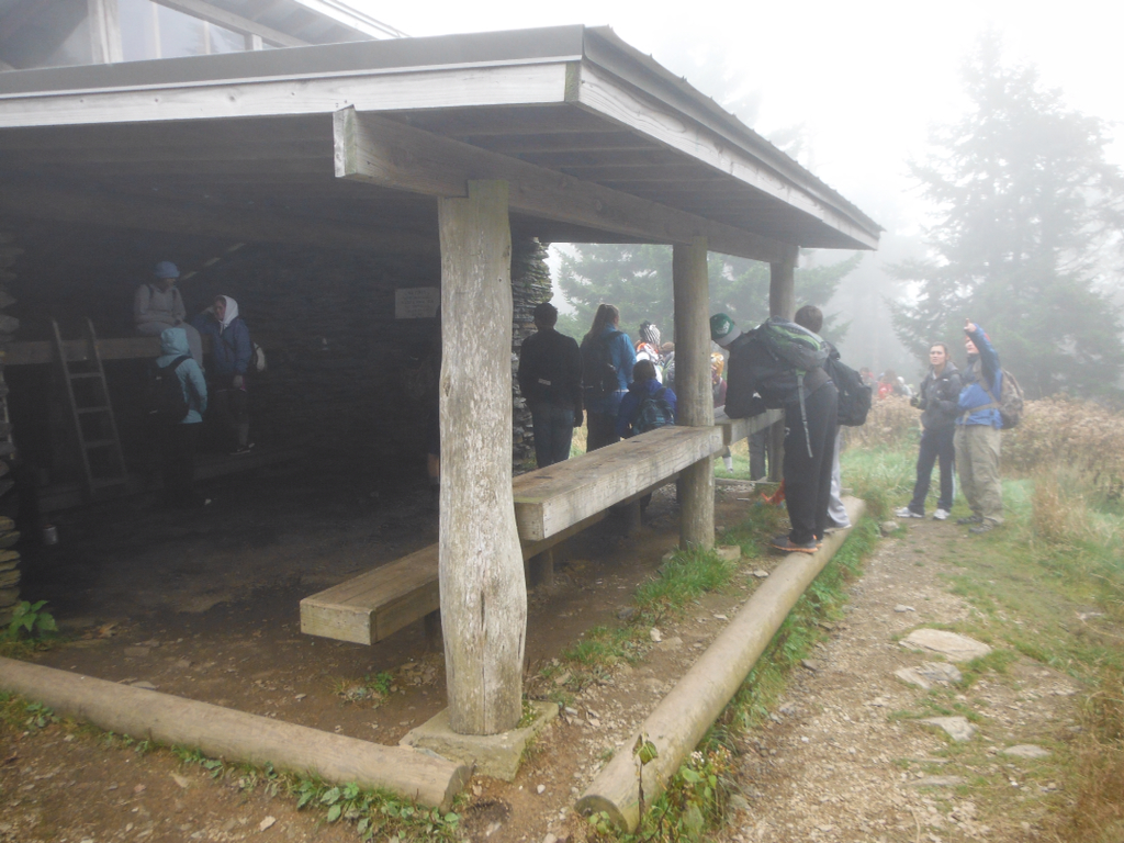
These students will continue to work on the scientific research behind our trip to the summit of Mt. LeConte in the coming month, and will put together presentations and proposals to share with the Park Service and perhaps the Friends of the Smokies, but I, and hopefully they, will forever cherish our time on the mountain. I know that this mountain will always hold a special place in my heart because of this experience. Someone once said, "Joy shared is joy magnified." The same thing definitely holds true for this magical mountain.
Wednesday, October 17, 2012
Sunday, September 23, 2012
Blue Ridge Mountain Sports Steps Up!
I just wanted to take a minute to share with you that Blue Ridge Mountain Sports in Farragut has stepped up to donate 35 Cliff Bars to the hike I wrote about in the last blog entry.
If you are in need of gear soon, stop in Blue Ridge Mountain Sports on Kingston Pike and let them know you appreciate their support of getting youngsters into the great outdoors. I know I will!
We are still in need of water bottles, Gatorade or Powerade, and monetary donations to purchase the kids an "I Hiked It" shirt at the top. If you have any ideas, feel free to share them with me.
If you are in need of gear soon, stop in Blue Ridge Mountain Sports on Kingston Pike and let them know you appreciate their support of getting youngsters into the great outdoors. I know I will!
We are still in need of water bottles, Gatorade or Powerade, and monetary donations to purchase the kids an "I Hiked It" shirt at the top. If you have any ideas, feel free to share them with me.
Tuesday, September 18, 2012
Call me crazy! Field trip to Mt. LeConte!
I may have totally lost my mind, but I just received word that my field trip request to take my Microbiology classes to the summit of Mt. LeConte has been approved! What that means is that I will be taking approximately 35 high school students on a 10-mile hike up and back on Alum Cave Bluff trail.
I am so proud of these students. I asked them to do some research on current events in the field of microbiology and several of them began discussing the emergence of the hantavirus out of Yosemite National Park and what a scary scenario that is. Hantavirus is carried by rats and mice; humans are exposed to the virus by breathing in dried feces or urine particles that are in the air in rodent-infested shelters and cabins in Yosemite. According to what I have read recently, this disease is lethal approximately 40% of the time, and survivors may suffer debilitating symptoms long after they have "recovered." My students began making the connection between the rat/mouse infestations in Yosemite Park shelters and cabins with conditions in the part of the Smokies with which some of them are familiar. They wondered if a rodent control program is in place in the LeConte cabins as well as in the shelters along the Appalachian Trail in Tennessee.
My students quickly decided that, as a part of our course work in Microbiology, they wanted to think like epidemiologists and investigate the conditions in Yosemite which have allowed the hantavirus to become such a problem and look at ways to prevent similar conditions from developing right in our own park. From that arose the idea that we would actually visit Mt. LeConte to gather information for their project. While we are up there, I hope to be able to get LeConte Lodge employees to meet with my students and provide some insight to whatever programs are in place relevant to rodent control or explain to my students the impediments that prevent such programs. I truly hope that park or lodge employees will appreciate the real-world relevance that such a project provides for these students and will honor my request.
What else does that mean? It means that I will be able to expose these students to the grandeur and beauty of one of my favorite places on earth. Mt. LeConte is special in many ways. The challenge of the hike up will encourage these kids to get in shape to the best of their ability between now and the day of our hike. The accomplishment they feel when they reach the summit will stay with them forever, as will the views they will experience if we are blessed with good weather at the top. It also means that many of these kids who have never even been to the Smokies, although they are practically in our backyard, will get to take what could turn out to be the trip of a lifetime!
I will be looking for some corporate sponsors to help us purchase things like Clif Bars, bananas, and water bottles. I'll also be looking for a company to provide breakfast biscuits and juice or milk for us to eat on the bus ride up to the trail head. In addition, I would LOVE for someone to donate enough money to purchase each student one of the "I Hiked It" shirts available at the LeConte Lodge store! I'll let you know who steps up and helps us out with this. The transportation and other expenses are more expensive than I thought they would be when I first considered the idea. If you have any ideas, please feel free to share them with me as I try to arrange a trip these kids can afford and will enjoy. Also, if you don't mind, pray or hope for great weather for us! :)
I am so proud of these students. I asked them to do some research on current events in the field of microbiology and several of them began discussing the emergence of the hantavirus out of Yosemite National Park and what a scary scenario that is. Hantavirus is carried by rats and mice; humans are exposed to the virus by breathing in dried feces or urine particles that are in the air in rodent-infested shelters and cabins in Yosemite. According to what I have read recently, this disease is lethal approximately 40% of the time, and survivors may suffer debilitating symptoms long after they have "recovered." My students began making the connection between the rat/mouse infestations in Yosemite Park shelters and cabins with conditions in the part of the Smokies with which some of them are familiar. They wondered if a rodent control program is in place in the LeConte cabins as well as in the shelters along the Appalachian Trail in Tennessee.
My students quickly decided that, as a part of our course work in Microbiology, they wanted to think like epidemiologists and investigate the conditions in Yosemite which have allowed the hantavirus to become such a problem and look at ways to prevent similar conditions from developing right in our own park. From that arose the idea that we would actually visit Mt. LeConte to gather information for their project. While we are up there, I hope to be able to get LeConte Lodge employees to meet with my students and provide some insight to whatever programs are in place relevant to rodent control or explain to my students the impediments that prevent such programs. I truly hope that park or lodge employees will appreciate the real-world relevance that such a project provides for these students and will honor my request.
What else does that mean? It means that I will be able to expose these students to the grandeur and beauty of one of my favorite places on earth. Mt. LeConte is special in many ways. The challenge of the hike up will encourage these kids to get in shape to the best of their ability between now and the day of our hike. The accomplishment they feel when they reach the summit will stay with them forever, as will the views they will experience if we are blessed with good weather at the top. It also means that many of these kids who have never even been to the Smokies, although they are practically in our backyard, will get to take what could turn out to be the trip of a lifetime!
I will be looking for some corporate sponsors to help us purchase things like Clif Bars, bananas, and water bottles. I'll also be looking for a company to provide breakfast biscuits and juice or milk for us to eat on the bus ride up to the trail head. In addition, I would LOVE for someone to donate enough money to purchase each student one of the "I Hiked It" shirts available at the LeConte Lodge store! I'll let you know who steps up and helps us out with this. The transportation and other expenses are more expensive than I thought they would be when I first considered the idea. If you have any ideas, please feel free to share them with me as I try to arrange a trip these kids can afford and will enjoy. Also, if you don't mind, pray or hope for great weather for us! :)
Sunday, September 16, 2012
Victory on the Appalachian Trail
Well, we finally did it! I don't know if anyone has noticed, but since my disastrous day on the AT in July, there haven't been anymore hiking posts. There has been one hike since then, but not until last week. It was a nice hike, but really just a warm up for yesterday's scheduled "redo" of the previously attempted hike from Clingman's Dome to Newfound Gap.
I swear I think I had a little touch of Post Traumatic Stress Disorder after the ordeal on the AT in July. If you haven't read about that hike, you might want to go back to those two posts in July about that trek. It was a mess. I was a mess! I simply couldn't bring myself to don my backpack and head up into the mountains again after such a debacle--for almost six weeks!
Last Saturday, even though there was a good chance of rain, we headed out for a short adventure doing the Old Sugarlands Trail and Twin Creeks Trail, finishing up with the Gatinburg Trail for a total of about 8 miles in low altitude conditions just in case storms moved in. The weather was muggy, but the hikes were pretty and proved to be a good re-entry into the world of hiking for me. It was great to be with my hiking buddies and out in the wilderness again.
Yesterday, we suited up, drove one car to Newfound Gap, continued on up Clingman's Dome Road, and were met with spectacular vistas from the parking lot! Azure skies streaked with jet streams contrasted over the cotton candy clouds creating a sea below us punctuated with mountaintop islands. Those views alone did much to encourage us and lift our hopes of a different type of day on the AT. Still, I perceived that we were all a little tentative. We were deliberate in deciding which of the three short connector hikes to take. Even with maps in hand and our experienced leader in the pack, the trailhead signs and map of this area are still somewhat confusing. We took the Forney Ridge path out of the parking lot to the connection with the AT skirting around and passing underneath the observation tower. When we came to the sign where we made our fateful wrong decision last time, we stopped for a photo op, consulted our maps once again, and then turned RIGHT on the Appalachian Trail--"right" in both meanings of the word!
Once on the trail in the right direction, we settled into our usual hiking rhythm with Kirsten and Andrea leading the group followed by Jennifer and me a little further back. We hike together for the most part on the flats, but on the extreme ups and downs, the pace I keep is a little slower than the two leaders. This part of the AT is, I believe, fairly typical of the AT in Tennessee. It's rough with rocks and roots; stairs of logs are laid into the path frequently with irregular rises which make passing up or down them difficult and hard on post-surgery knees. I have grown to hate those steps! Those steps were my nemesis on the previous AT disaster, and I have no greater love for them after yesterday's hike. However, I do appreciate those trail maintenance volunteers who worked so hard to put them in place. Without them, the trail would probably be impassable in places. So that is what I ended up thinking about as I climbed or descended them yesterday even as my knee was screaming at me with each step.
| Rather tenuous footing on the AT |
| One of the varieties of Gentian that blooms up here |
| The wall at Newfound Gap skirted with Pale Jewelweed |
| Spotted Jewelweed |
I ended this hike victorious--victorious over the part of me that was crushed on that fateful day in July which had prevented me from coming back to my mountains. Victorious over the section of the AT that had intimidated me for 6 weeks. I was also victorious over my inexperience, having
learned valuable lessons and survived
virtually unscathed. Here's to perseverance! Here's to great friends and hiking buddies! Here's to victory!
Wednesday, August 29, 2012
Snakebite Precautions and First Aid
![]() |
| Timber Rattlesnake--notice the wide head |
Out Alive: Bitten by a Rattlesnake
http://www.backpacker.com/out-alive-bitten-by-a-rattlesnake/survival/16703
Through researching the internet, I have concluded that if I or one of my hiking companions is struck by either of the two poisonous snakes found in the Smokies, I need to remember to do the following:
Do's
*Remain calm. Yeah, right! However, this will slow the spread of the venom through the body if we can pull it off.
*Remove all jewelry that may be difficult to remove after the area swells.
*Try to immobilize the area as much as possible. For instance, make a splint or sling if the bite is on the arm.
*Keep the affected area at or below the level of the heart.
*One of my hiking partners carries a snake bite kit. Although there is some confusion on the web as to the effectiveness, National Institutes of Health does recommend using one like the ones made by Sawyer. I may look into buying one of those.
*If it is possible, the victim can be carried out. However, if it means a major delay in getting help, it is better that the victim walk out.
Don'ts
*Do not cut the bite wound with a knife or anything else.
*Do not attempt to suck the poison out of the wound.
*Do not waste time trying to kill and catch the snake. (I wouldn't be tempted to do this anyway, but that is the advice I've found on the web.) But do try to remember the color and shape (especially of the head) to help rescue personnel identify the snake.
*Do not apply ice packs to the wound.
*Do not apply a tourniquet. There is some confusion here, so I suggest you do your own reading on this one. I, personally, will be afraid to apply one with my limited knowledge of first aid.
Important recommendations:
*Consider taking a Wilderness First Aid Course--something I would love to do soon!
*Pay close attention to the area in which you hike. Be aware of where snakes might be and be on the lookout for them.
*Never reach into crevices in rocks or under piles of rocks or brush where snakes may be hiding.
*If you have to walk through an area where you cannot see your feet, use your hiking pole in front of you to give the snake time to get out of your way.
*As a caveat, I am not a medical professional. I simply tried to gather information for my own use on the trails. I did use information from what I consider to be professional sites, primarily the Mayo Clinic and National Institutes of Health.
![]() |
| Copperhead--the only other poisonous snake in the Smokies |
Wednesday, August 22, 2012
Stress Relief of the Greenway Kind
![]() |
| A restful fountain in Springbrook Park on Maryville-Alcoa Greenway |
After watching for a few minutes we mounted our bikes and entered the greenway. This trail is a wide, probably 8-foot in most places, paved asphalt trail with only a few minor grade changes. The path gently twists and turns, following for quite a ways along a creek, meandering through woods and wetlands, crossing some nicely maintained bridges, and finally taking a break at another small body of water in downtown Maryville populated by another group of ducks and geese. The trail goes on beyond this spot, but we turned around here. I've only been on the other end of this greenway one time before and that was with a couple who are very familiar with the greenway. I remember it being more difficult to find and follow after that point, so tonight we turned back. I hope to ride it again on Saturday with another friend who will want to do more miles, so we may try the other end then. Tonight however, we began at Springbrook Park and rode about 10 miles along the greenway to downtown Maryville, around some side trails, and back to the truck.
I don't know what it is about biking, but it is one of my favorite activities when I've had a stress-filled day. Nothing relaxes me quite as thoroughly as cruising along on my Cannondale Quick, especially when surrounded by beautiful scenery like that found on the greenways here in Knoxville and Alcoa. I do wish that the powers that be would approve and build enough greenways so that you could ride 15-20 miles at a time without having to travel the narrow and heavily trafficked roads of this area. Riding on the road still makes me nervous, although I am beginning to do a little more if it. I much prefer the greenways, complete with their green grass fields; wildlife such as birds, rabbits, and squirrels; and stream crossings. To me, that is the perfect recipe for stress relief--stress relief of the greenway kind!
Monday, August 6, 2012
One Month Later--Great Smoky Mountains Storm
I finally got up the nerve this weekend to visit my beloved Cade's Cove region of the Smokies, something I had not done since the storm passed through almost a month ago, downing thousands of trees and killing two people and injuring others. I still pray for those folks and their families and hope for the best for all of those affected. I had been to the park, but only to the Newfound Gap area which was untouched. Honestly, I was not prepared for what I saw!
One of my favorite trails, especially in the spring when the early wildflowers are blooming, Chestnut Top Trail, was the first severely damaged area I came to as I passed through and beyond Townsend. In early spring, the first half mile of this trail is covered in blood root, trillium, Solomon's seal, spring beauty and many other varieties of the tiny blessings that wait for the observant hiker or photographer.
As of right now, this trail is closed, and with good reason! I have heard that parts of the trail are well under way in the reconstruction process, but I wonder what they will do to this bank that has virtually been sheered off, leaving almost none of the original trail intact for 30 yards or so that I could see from the road. I also wonder how long the remaining part of the trail can withstand rains and weather that the fall and winter will bring with no tree roots to hold that bank in place.
Another of my favorite trails is affected by the damage too, and that is the Scott Mountain Trail that runs along the ridge line down from the Cade's Cove area back toward Townsend. Somewhere on that trail was one of the largest trees I have ever seen in these mountains. I believe it is a tulip poplar, but I could be mistaken about that. Trees are not my forte when it comes to identification of the flora of my mountains. However, this tree is one that makes you stand at its base in awe of its girth and the length of its life standing on that slope.
I stopped four different park rangers while I was there to see if anyone knows the fate of that tree up on Scott Mountain. Sadly, I got the idea that none of the four of them had ever seen that tree. None of them could tell me of its fate in the wake of the storm. I sincerely hope it is still standing. It would be a shame if it was among the casualties. I just hope that the winds hit somewhere else along that ridge because I cannot imagine that old man of the forest being vey flexible, something I would imagine it would have to be to survive such force of nature.
As I made my way up Laurel Creek Road, there were times when you would never have thought such a storm had ripped through the area. Whole regions seemed untouched. Then, seemingly at random, entire hillsides were littered with the carcasses of what once were beautiful deciduous and evergreen trees reaching to the sky. No more! Now they lay askew, reminding me of the game I once played when I was a child. These hillsides looked like children had begun a game of Pick Up Sticks and had left their pieces scattered amongst the laurels and the rhododendron. Many of the trunks that remained standing were stripped of foliage, broken, or bent.
Somewhere underneath all of the debris lies what used to be a pretty fair trout stream. I had not taken the time to fish it yet, but I had been told that it was a great place for a woman to fish by herself and my plans were to do just that when the weather cooled. The stream runs alongside the road on the way to Cades Cove, and if you wait until the waters are too cool for folks to swim in them, they are easily accessible and also provide enough nearby road traffic to get help if one should fall and get hurt. When you get my age and want to fish while hubby is at work, that's something to think about. However, I'm not sure what all this debris will do to the trout waters. I know it will have made whole stretches of it difficult to access at best.
The good news is that once I crested the top of Laurel Creek Road and began to drop down into the Cade's Cove area, I saw very few newly fallen trees. This part of the park seems to be largely unscathed. I saw no damage to the structures at the picnic area or the store and amphitheater at the campground. I did not go around the loop road or through the campground but all seemed to be very normal there. By the way, there was no damage to the ice cream machine in the shop there at the campground. I had to make sure that it was unaffected, and I am pleased to report that the ice cream is still creamy and piled high atop those cones!
Let me just say that kudos need to go out to all those workers who helped clear the roads through the park in those first few days. I cannot imagine how many trees must have littered and blocked both Laurel Creek Road and Little River Road. I understand that many nearby private contractors and just everyday folks came out bearing construction vehicles and chainsaws to help clear the debris and restore access to what remains as one of the most spectacular places in America. It remains impressive in every way, but now, in addition to its beauty, there is staggering evidence of the power of nature.
One of my favorite trails, especially in the spring when the early wildflowers are blooming, Chestnut Top Trail, was the first severely damaged area I came to as I passed through and beyond Townsend. In early spring, the first half mile of this trail is covered in blood root, trillium, Solomon's seal, spring beauty and many other varieties of the tiny blessings that wait for the observant hiker or photographer.
As of right now, this trail is closed, and with good reason! I have heard that parts of the trail are well under way in the reconstruction process, but I wonder what they will do to this bank that has virtually been sheered off, leaving almost none of the original trail intact for 30 yards or so that I could see from the road. I also wonder how long the remaining part of the trail can withstand rains and weather that the fall and winter will bring with no tree roots to hold that bank in place.
Another of my favorite trails is affected by the damage too, and that is the Scott Mountain Trail that runs along the ridge line down from the Cade's Cove area back toward Townsend. Somewhere on that trail was one of the largest trees I have ever seen in these mountains. I believe it is a tulip poplar, but I could be mistaken about that. Trees are not my forte when it comes to identification of the flora of my mountains. However, this tree is one that makes you stand at its base in awe of its girth and the length of its life standing on that slope.
I stopped four different park rangers while I was there to see if anyone knows the fate of that tree up on Scott Mountain. Sadly, I got the idea that none of the four of them had ever seen that tree. None of them could tell me of its fate in the wake of the storm. I sincerely hope it is still standing. It would be a shame if it was among the casualties. I just hope that the winds hit somewhere else along that ridge because I cannot imagine that old man of the forest being vey flexible, something I would imagine it would have to be to survive such force of nature.
As I made my way up Laurel Creek Road, there were times when you would never have thought such a storm had ripped through the area. Whole regions seemed untouched. Then, seemingly at random, entire hillsides were littered with the carcasses of what once were beautiful deciduous and evergreen trees reaching to the sky. No more! Now they lay askew, reminding me of the game I once played when I was a child. These hillsides looked like children had begun a game of Pick Up Sticks and had left their pieces scattered amongst the laurels and the rhododendron. Many of the trunks that remained standing were stripped of foliage, broken, or bent.
Somewhere underneath all of the debris lies what used to be a pretty fair trout stream. I had not taken the time to fish it yet, but I had been told that it was a great place for a woman to fish by herself and my plans were to do just that when the weather cooled. The stream runs alongside the road on the way to Cades Cove, and if you wait until the waters are too cool for folks to swim in them, they are easily accessible and also provide enough nearby road traffic to get help if one should fall and get hurt. When you get my age and want to fish while hubby is at work, that's something to think about. However, I'm not sure what all this debris will do to the trout waters. I know it will have made whole stretches of it difficult to access at best.
The good news is that once I crested the top of Laurel Creek Road and began to drop down into the Cade's Cove area, I saw very few newly fallen trees. This part of the park seems to be largely unscathed. I saw no damage to the structures at the picnic area or the store and amphitheater at the campground. I did not go around the loop road or through the campground but all seemed to be very normal there. By the way, there was no damage to the ice cream machine in the shop there at the campground. I had to make sure that it was unaffected, and I am pleased to report that the ice cream is still creamy and piled high atop those cones!
Let me just say that kudos need to go out to all those workers who helped clear the roads through the park in those first few days. I cannot imagine how many trees must have littered and blocked both Laurel Creek Road and Little River Road. I understand that many nearby private contractors and just everyday folks came out bearing construction vehicles and chainsaws to help clear the debris and restore access to what remains as one of the most spectacular places in America. It remains impressive in every way, but now, in addition to its beauty, there is staggering evidence of the power of nature.
Subscribe to:
Posts (Atom)


