The Trail, its Sights, and Shelters (South to North)
Newfound Gap to Peck's Corner
The first mile of your hike north on the AT from Newfound Gap will likely be pretty crowded. Most everyone who drives up to the Gap for views from the parking lot will want to take a few steps on the famous Appalachian Trail, so just be prepared for the typical "are you a thru-hiker" questions! The crowds will thin considerably by the end of the first mile or so, but will become almost non-existent by the time you pass Charlie's Bunion at the 4-mile point. More about that in a moment!

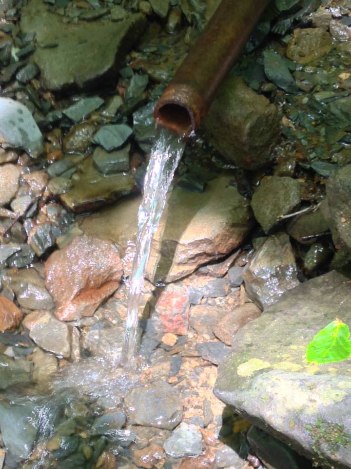
The climb up from the parking lot is a breeze compared to the climb up from Fontana Dam, so you will definitely enjoy this day! This section of trail follows the ridgeline and offers spectacular vistas repeatedly on either side, first with North Carolina to the right and later with Tennessee to your left. If you did not take a night or two in Gatlinburg and instead hiked up from Silers Bald or Double Spring Gap shelters, you might be aiming for Icewater Shelter as your destination for this night. Just a heads up...it will likely be full, especially on weekends, but often during the week as well. This shelter is so close to the road and so easily accessible, it is a favorite for, shall we say, less-than-experienced hikers. With that said, you might find yourself surrounded by partiers and folks who don't understand what hiker midnight means because they've never put in a long hard day on ANY trail. However, in addition to having a very nice privy (even handicap-accessible if I remember correctly), the best part about Icewater Spring shelter is that it offers some of the best sunrises in the entire Park, so that trade-off might be worth having to put up with a bit of partying. The water source at Icewater Spring tastes just like you would expect. It's a pipe spring coming out of the ground literally crossing the AT just a few yards north of the shelter. It is cold and delicious! But, as always, treat any water you drink while in the backcountry.

Whether you stop for the night at Icewater Spring or not, hiking on beyond it, you will soon come to the side trail for one of my very favorite locations in the entire Park. A very short trail leads off to your left and bears the sign marking Charlie's Bunion. Please do NOT miss this spot! It is SO worth it, and you will want the picture from the rocks reaching out over a massive overlook with Mt. LeConte on your left and the Greenbrier region of the Smokies in front and beyond. On a clear day, from Charlie's Bunion, you can almost literally see forever, or so it seems. The views, in my opinion, are better than those from McAfee Knob because you are 2400' higher here. Standing, or sitting if the winds are fierce, out there on the rock outcropping, you will feel small and unimportant which is, in my opinion, good for the soul on occasion.
You might wish to know that these rocks were laid bare by a 1925 wildfire so hot it killed everything living there and rendered the soil incapable of regrowing vegetation. Four years later, a thunderstorm dumped a significant amount of water in a short period of time, washing the remaining soil down the cliffs, exposing what we now call the Bunion. Those of us who love the Smokies do wonder if a similar fate awaits the Chimney Tops and Bullhead regions so ravaged by wildfires back in November 2016. But you will probably not notice the devastation of that area unless you hitch or shuttle to and from Gatlinburg from Newfound Gap. The AT does not pass through the scorched area itself.
Once you have soaked up the vistas from Charlie's Bunion, you return to the trail and will soon cross the Sawteeth. There are spots along the trail between Charlie's Bunion and the next shelter at Peck's Corner that are very narrow strips of trail on a ridgeline seemingly no wider than the width of one hiker and his/her hiking poles. It does NOT feel scary though, so don't worry about that. There are brush and myrtle bushes along both sides of the trail, so it doesn't feel like you're going to fall off the ridge. One other notable feature you will pass is Bradley's View, a flat Anakeesta rock outcropping that provides both a resting spot and phenomenal views down into the North Carolina Smokies and foothills.
Peck's Corner shelter lies about .4 miles down the Hughes Ridge trail that intersects with the AT. This shelter does have a privy and a good water source, and if you climb up the little knoll just past the turn off to the shelter from Hughes Ridge trail and past the privy, you can find decent cell reception (which truly is a bit unusual in the Smokies). That is also a nice spot to go to for sunrise if you are inclined to chase them as I am.
Peck's Corner to Tricorner Knob
Just so you know, you are now in the most remote region of the Smoky Mountains, perhaps as remote as any part of the trail you will encounter until you arrive at the 100-mile wilderness in Maine. No roads and only a few seldom-traveled trails connect with the AT from here until the Cosby area. THIS is my favorite part of the entire Park!
 |
| The view from Eagle Rocks |
 About a mile after you leave the Peck's Corner and Hughes Ridge intersection, you will come to another open rock outcropping which affords more excellent views. This spot is Eagle Rocks, and you will find a geological marker there telling you the elevation at which you stand. It makes for a nice photo as do those phenomenal vistas you will be enjoying. The walk between Peck's Corner and Tricorner Knob skirts around the two summits of Mt. Sequoyah and Mt. Chapman and traverses through virgin forests, never logged, which cannot be said of the part of the Smokies you have already come through. These old-growth forests are simply magical! Stop along the way and take it all in--the sights, the smells, the mist, the connection with ancient time.
 After climbing and then descending from the shoulders of Mt. Chapman, there is one short, final ascent to Tricorner Knob shelter. This shelter has a pipe-spring coming from the hillside just in front of the shelter and a privy large enough to make a nice changing room just a short distance down a flat (which is much appreciated after Peck's Corner), well-beaten path.
The bear cables are down the same wide path to the privy, making them easy to access as well. The nights I have stayed in this shelter, we've had roaring fires in the fireplace, another welcome accommodation considering it is usually colder here than anywhere else along the AT in the Smokies.
From Tricorner Knob to Cosby Knob

The trail you take when you leave Tricorner Knob and head toward the Cosby area will offer respite from the typical Smokies climbs. While experiencing an overall loss of elevation, you will cross two interesting areas you might not otherwise notice or understand. About 2.7 miles from Tricorner Knob shelter, you will come to a flat area across which some concrete rectangular slabs have been laid. The trail crosses right in the middle of them. This is an old helipad created after the wreck of a military jet in 1984, the remnants of which you will see in a few minutes if you know where to look for it. The helipad is another wonderful place to take off the packs and take a snack or breakfast break. On a sunny day, it would be a nice place to dry out your gear if you've had rain on previous days.
Once you leave the helipad, you will hike a short distance and come to some well-built stone stairs.

Walking on, you will pass into now less mature forests, an area that once again, had been logged heavily in the years before the National Park. After you pass the intersection with Camel Gap Trail, you will climb for a little bit before reaching the next shelter, Cosby Knob, at a distance of 7.7 miles from Tricorner Knob shelter. This shelter is used regularly by local Park visitors and is known for its not-shy mice and, in the summer, frequent visits by bears. I once woke to the scampering of tiny feet across my sleeping bag, raised my hand inside my bag to knock him off, and sent him flying with a thud into the shelter wall beside me. I have not stayed there since. This shelter closes almost every summer due to aggressive bear activity, so be sure to check the status if you are planning to stay here or be prepared to keep walking.

Cosby Knob to Davenport Gap
 |
| Pink Lady Slippers can be seen here in early June |

The Mt. Cammerer Lookout Tower, crafted from stones blasted and shaped by workers of the Civilian Conservation Corp in 1937, was used as a fire lookout until 1960, but is no longer used for that now. You can climb up those white rocks to the lookout, walk around the structure on the railed decking, and even go into the building. Sadly, you cannot camp here to protect the structure from overuse and abuse. As you can see when you enter, it has already been defaced by visitors who hold no respect for the hard labor that built this fine and unique structure. This building is definitely worth the 1.2 mile easy round trip if you have the time. You can keep in mind as you decide, that it is an entirely downhill trek from this point to the northern boundary of the Park. Go out to Mt. Cammerer Lookout! You will not be disappointed!
The remainder of your time in the Smokies will be, literally, a walk in the Park. This pleasant section of trail descends comfortably until you come to the final shelter, Davenport Gap shelter. This is the only shelter remaining in the Smokies that still has the chainlink fence surrounding it. Most, if not all, shelters on the AT at one time sported these chainlink surrounds which were designed to keep bears and humans carefully separated from one another. The flaw in the thinking here, though, turned out to be that designers had no idea people safely ensconced within the fences would FEED bears through the fence. However, that is by most accounts what became the undoing of the design. As you can imagine, what ended up happening was that the people became virtual prisoners within the fencing because the bears became conditioned to being fed. The Park Service has long since removed all such fences, except, for some unknown reason, this one, and instead have placed the bear cables for all hikers to use to hang food and anything bears might THINK are food. Please do abide by the restrictions regarding no food in the shelters. I would hate to see the Smokies become one of the places where you have to hike through carrying a bulky bear canister.
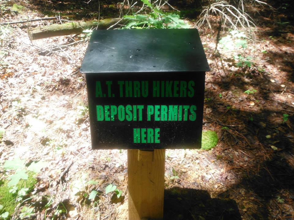
From Davenport Gap shelter it is approximately one mile to the end of the AT in the Smokies and the spot where you can drop off your no-longer-needed copy of your permit. If you continue hiking on from here, it is an easy 2.7 miles to Standing Bear Hostel where you can get a little resupply or enjoy a night in that very unique setting. I have used them several times for shuttles and they are really nice folks. If you are there, look for Lulu, the Boston Terrier, and throw her a rock or stick for me!
I sincerely hope this series has helped you with your planning of your thru or section hike of Great Smoky Mountains National Park. May you be blessed with bluebird skies and moderate temperatures! If you have further questions, feel free to comment below. Happy trails!