Well, I've had to bow out on two hikes now as a result of a shin splint. Two weeks ago after the hike with all those water crossings, I felt the best I've ever felt after a hike! And that was no EASY hike! So the next day in an honest effort to lose the extra weight that is so obvious in these hiking pictures, I went to the gym, hopped on the arc trainer, opened my iPad to my new book, AWOL on the Appalachian Trail, and did 30 minutes of strength training. That 30 minutes went by so fast I was amazed and actually thought "it's gonna be easy to get in shape like this!".
Well, so much for that theory! The next morning I woke to severe pain and restricted movement in my left leg that I was totally not expecting. It was all I could do to move around that huge school building I work in. For the last week and a half I've babied my leg, put on heat or ice depending on what I felt I needed, and hoped to be able to hike during Spring Break. I've cancelled two hikes now: one last weekend and one tomorrow. I finally went to the doctor today just to be sure there wasn't something bad wrong.
So the diagnosis is what I expected and the knot on the back of that leg is apparently just fatty tissue. I am cleared to ride the Virginia Creeper Trail on Tuesday, but Doc told me to go easier on the hiking. Guess I need to hike with my hubby who doesn't think hiking is a race! I love my Bucket Brigade hiking buddies and I will hike with them, but I hope they will allow me to ease back into our routine.
Friday, March 16, 2012
Sunday, March 4, 2012
Water Crossings and Downed Trees--3.3.12
 |
| First of many water crossings on this day |
This hike was bound to be unique simply because it almost didn't/couldn't happen! On Friday evening tornadoes and severe thunderstorms tore through the East Tennessee area. I heard that Wears' Valley had a tornado sighting, and I figured that might be the end of our hike. The storms did cause the closing of Little River Road, but thankfully, the hike we had planned for Saturday required access via Laurel Creek Road instead. Saturday morning dawned clear and beautiful, so we piled in the truck and headed to the mountains after checking Twitter to make sure no more roads were closed.
 |
| Up, up, and away--on Rich Mountain Trail. |
After drying our feet and putting our boots back on, we began the climb up Crooked Arm Ridge. This ridge rises at a rate of about 670 feet per mile, but there are enough nice views along the way to provide photo opps (which double as resting opps!) to make it really a very pleasant climb. Before long we came to our first real breaking spot at the crest of this ridge. Here we enjoyed absolutely beautiful views of Cades Cove from about 3100 feet above the valley. It was exquisite!
 |
| Looking down on Cades Cove from Crooked Arm Ridge Trail |
Along the route today, we had to maneuver over and under and around several fallen trees. I guess the winds from the storms the night before were powerful enough to split or dislodge some limbs or tree trunks. Some of them were very obviously new breaks.

After our snack break we resumed climbing just a little further to the intersection with Scott Mountain Trail. This turned out to be one of my favorite trails I've ever hike in these mountains. This trail travels mostly along the ridge that acts as the dividing line between the National Park and private property. I loved walking along that ridge. It reminded me of the ridge that we hiked on our trip last summer along the Appalachian Trail. Look to your right...Smoky Mountain. Look to your left into a valley of quaint homes and pastureland. Well, one of the homes wasn't so "quaint"! At one point, I looked up from the path to see a beautiful log home built on the very top of Scott Mountain. My DREAM home! It was anything but quaint!
Scott Mountain Trail had many appealing features. There were quite a few water crossings, although these were small enough to rock hop and I'm not sure many of them are there in dry weather. It also was home to Campsite #6 which sits right atop the ridge and would be a fantastic place to camp. I didn't get to go up and check it out because there was a hiker already up there, but that was a beautiful place. Also along this trail was one of the largest trees I've ever seen in the Smokies. I don't know what kind it is unless it's a very large Tulip Poplar. Its branches were so high up in the sky, I couldn't tell exactly what the blossoms that appeared to be breaking out really looked like. I believe it would have taken all four of my hiking group to reach around it with our fingers touching. Two of us couldn't even come close. It was awe-inspiring to say the least.
 |
| Very old Tulip Poplar |
 |
| Scott Mountain Trail |
At the end of Scott Mountain Trail, we stopped to have our lunch and were tempted by a picnic table which apparently belonged to a house which sits at that intersection of Scott Mountain Trail, Schoolhouse Gap Trail and a little gravel road that leads off the mountain down into the valley we'd been looking into for the last mile. Andrea refused to eat on a picnic table that was personal property, although I bet the owners put it there for hikers to use actually. Therefore, we propped on some large rocks nearby and ate our peanut butter sandwiches, trail mix, and beef jerky before we made our way down this leg of the hike. Schoolhouse Gap Trail eventually took us to the juncture of the little, heretofore unmarked trail that leads down into White Oak Sinks where I want us to visit this spring in search of wildflowers. This is the place Kacey and I went to with a park ranger during one of our early adventures with the Spring Wildflower Pilgrimage. I can't wait to go back now that I've found the trailhead. After that, we were almost back to our second car that we had left at the trailhead of Schoolhouse Gap Trail. This stone bridge is what Laurel Creek Road crosses the creek on and it is just one example of some of the architectural elements in this park that I love so much.
 |
| Laurel Creek Bridge |
Sunday, February 19, 2012
Cade's Cove to Tremont

At the end of Crib Gap Trail, we began an almost two mile ascent up the western slope of Bote Mountain on Lead Cove Trail. We wondered as we wandered along this trail if it were pronounced lead as in "to lead someone along" or if it were pronounced like the metal. Come to find out, it is named after the lead ore that was once mined here. This trail is a steady ascent of about 1400 ft in 1.8 miles. This required several stops along the way to let the pounding heartbeat in my ears subside and let my lungs fill up with oxygen again. We did notice some nice views along the way and some massive tulip poplars beginning to bloom way above our heads. We were all glad to see the top of Bote Mountain at the small clearing where Lead Cove and Bote Mountain Trails come together. After kissing the signpost, we stopped for lunch--really just an excuse to let our rubbery legs become a bit more stable before moving on.
 |
| Glad to see the top of Lead Cove Trail! |
The views at that summit were almost 360 degrees, and I am kicking myself for not remembering that my new iPhone 4S has a video camera in it. That would have been a nice place to get some video, but I didn't think about it until probably half a mile down the Bote Mountain Trail. Laura said she'd wait for me if I wanted to go back up and get the video, but I declined her invitation to do that. The Bote Mountain Trail is wide, but it was terribly rocky. Loose rocks about 4 or 5 inches or larger in diameter absolutely littered the trail making the descent tricky. Numerous times I was glad my hiking boots were tall enough to provide significant ankle support. I was glad to get to the point where we left Bote Mountain Trail and got on the West Prong Trail. This little trail was narrow, but the leaves that covered it were much nicer that the rocks that characterized the Bote Mountain Trail giving it the attributes that I think of most when I think of hiking in the Smokies.
This beautiful little trail led us down to Backcountry Campsite #18. I have heard about these campsites for many years, but this is the first one I'd seen. It was absolutely beautiful! The Middle Prong of the Little River runs right through it and there are nice areas for four different camping groups to set up camp. At least two of the campsites had bear bag hanging racks mounted in the trees, which would eliminate one of the major challenges of backcountry camping--keeping the bears from getting your food! I do wish that the campsites included an outhouse like the shelters along the Appalachian Trail have, because several of us would have benefited from that feature about that time in our hike.
 |
| Great Smoky Mountains National Park Backcountry Campsite #18 |
 |
| Footbridge at Backcountry Campsite #18 |
After spending some time exploring the campsite, we crossed the Middle Prong along one of those marvelous log bridges common in the Smokies and began the final leg of our journey. The trail, still West Prong Trail, maintained its characteristic narrow and switchback nature as it made its way up another ridge. We passed a couple with their young son about 20 minutes into this last part of our journey. We told them how beautiful the river was not far below them. You could tell that mom was less than thrilled to hear that, but her son really needed to make that trek and see it for himself. The boy's dad seemed excited to be taking him there, and I believe he was glad to get the encouragement. Sorry lady--I hope you toughed it out for your son's sake.
By this time, over 6 hours into our hike, every fiber in my calves was burning and my shoulders were aching too. Reaching the Tremont parking lot was a welcome event, but this hike had been enjoyable. Laura and I had the discussion along the way that this hike (for new miles) was very different from a destination hike, like Mt. Leconte. Even though Leconte was longer, it was a much more interesting and enjoyable hike. I seemed to struggle more with this hike than I did the last couple hikes although the distance and terrain was about the same. I've got to do a better job with between hike training and nutrition. That's something I have to work on over the coming weeks.
After loading back up into Kirsten's car, we made a quick stop at Tremont Institute's gift shop where Laura got her a map to highlight the trails she's hiked on and Kirsten found me a copy of Day Hiker's Guide to All the Trails in the Smoky Mountains. This is the book we are using to help us decide how to make the most out of our trips in terms of trying to hike the 900. She bought it for me. In return, she said just hike with her and if anything bad ever happens to her on a hike, make sure we either get her out or get someone else to get her out! Not a bad trade either way.
 | |
| Small falls into the Middle Prong |
 |
| Middle Prong of the Little River |
Once back in our car, before driving back to Knoxville, we decided to drive up the Middle Prong road which runs along an old railroad where a logging community once thrived. Since Andrea is a history teacher and major geneology buff, we purchased the little guide that goes along with the road tour and she read to us the history of the settlement as we made our way up the gravel road. It was interesting to get a glimpse of life the way it would have been in the 1930s in these mountains. Some of the prettiest sites of the day came along that road. The Middle Prong of the Little River is as pretty as any mountain stream I've ever seen. I will be returning here with my husband to fish this river this spring. It looks quite promising. Also, it leads up to the juncture with Lynn Camp Prong which is currently closed to fishermen. In this stream there is a concerted effort to rebuild the population of the native Brook Trout. Someday, I hope Bunk and I will return to Lynn Camp Prong to catch and release a few native brookies!
Saturday, February 4, 2012
The GSMNP 900?!? No promises; NEW miles!
Ok, so my little hiking group has a new goal (sort of)! The Great Smoky Mountains National Park has 900 miles of official trails that are now calling our name. Our hikes have taken on new direction, and new meaning. Some of us have officially, Andrea and Kirsten, decided they want to try to hike all 900 miles over the coming years. Because I want to do so many other things too, like Appalachian Trail hiking, bike riding, fly fishing--just to name a few, I haven't chosen to accept that challenge at this time.
 I will probably never do all 900, and that will be ok with me. However, what I have undertaken as my challenge is to log as many new miles as possible on the hikes that I do in the Smokies now. Currently, to the best of my ability, I have recreated my hiking adventures since moving back to Tennessee and have hiked 61.8 of the 900 miles of trails right here in my backyard. I have hiked over a hundred total miles, but much of that was repeat mileage. For instance, when I hiked to Grotto Falls and back, I covered 7 miles, but only 3.5 of those were new miles. Same with Mt. Leconte--total of 10 miles, but only 5 new miles.
This past weekend our group did a loop hike that began about a couple miles down the mountain from the entrance to Cades Cove. We hiked Finley Cane trail to Bote Mountain trail to Schoolhouse Gap trail and then traversed across Turkeypen Ridge, returning to our cars a total of 8.9 miles later. On this day, we covered 7.8 new miles that none of us had ever hiked before.
 Our hike was relaxing and not nearly as steep as climbing Chinquapin Ridge on the Walker Sisters hike a couple weeks earlier. Our pace was quick though. With only four hikers on this day, those who usually break out and end up waiting for the rest of us at waypoints along the hike stayed closer. That challenged the older or less experienced members of the group to walk more briskly than usual to keep from hindering the youngsters. I was proud of the pace I was able to sustain, but I don't feel like I get to see as much when I walk that quickly. Also, we never stopped to sit down for even a minute, so my conditioning is getting better, something that should serve me well this summer when, hopefully, we do another section of the AT.
 This hike was characterized by several water crossings and since we've had a good bit of rain lately, they were challenges in the rock-hopping department. In fact, the last one (thankfully it was the last or we'd have had wet feet all day) wasn't a rock hop at all. It was just a wade on tiptoes and hope your boots are tall enough to keep the river out. Mine were great! Only the top of my sock got wet on one foot, but one of our hikers had on low-cut hiking shoes and she was soaked. That water was pretty cold too, seeing as we did the hike in January! She was glad to get back to the car where we found her some dry socks.

One nice surprise on this hike though, due to all the rain, was an unexpected waterfall on the Turkeypen Ridge trail. I'm not sure that it would be there at all on a day when weather had been dry for a while, so I felt privileged to stand and watch it's somewhat ethereal beauty. It was quite pretty how it cascaded down the mountain, changing course when it hit a section of large rock outcroppings, veering off into what was almost a cave-like opening available to it as it rerouted around the boulders.

 I find myself feeling very fortunate to have the camaraderie of such a wonderful group of ladies to hike with during this transition time in my life. This is definitely helping to fill the void left by children who are growing up, moved out, and needing me less (or at least in different ways--seems like all they really need me for right now is money! And that's ok, too, for now). I am sort of remaking myself, similar to the way they are finding their way into their futures. I, too, feel like I'm finding new paths into mine. And I'm liking it!

This past weekend our group did a loop hike that began about a couple miles down the mountain from the entrance to Cades Cove. We hiked Finley Cane trail to Bote Mountain trail to Schoolhouse Gap trail and then traversed across Turkeypen Ridge, returning to our cars a total of 8.9 miles later. On this day, we covered 7.8 new miles that none of us had ever hiked before.


One nice surprise on this hike though, due to all the rain, was an unexpected waterfall on the Turkeypen Ridge trail. I'm not sure that it would be there at all on a day when weather had been dry for a while, so I felt privileged to stand and watch it's somewhat ethereal beauty. It was quite pretty how it cascaded down the mountain, changing course when it hit a section of large rock outcroppings, veering off into what was almost a cave-like opening available to it as it rerouted around the boulders.


Monday, January 16, 2012
Walker Sisters'Sister's Homeplace to Laurel Falls
 |
| Walker Sister's Cabin |
 |
| The Watsons |
 |
| Chinquapin Ridge |
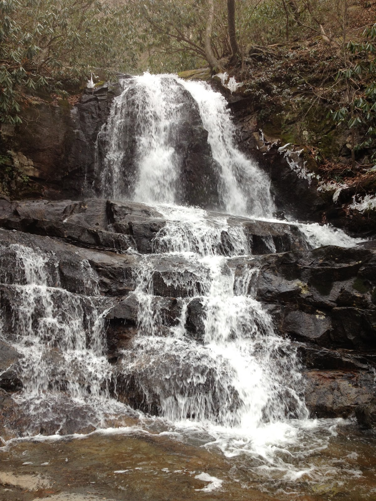 |
| Laurel Falls |
After hiking another 1.8 miles, this time downhill, we reached the most visited falls in the park: Laurel Fallls. This falls plummets spectacularly 75 feet from the top, past the viewing crossing and down to the stream that carries the water down to Little River. We stopped here to eat the lunches we had packed, but it began to get pretty cold when we weren't walking. From there it was only another 1.4 miles to the parking area where we had left a car to shuttle us back to Metcalf Bottoms. On the way down though, we did witness the fall of a tree in the woods, and it made me think of the shirt I bought Bunk once, well actually twice, that said: if a man speaks in the forest and there is no woman around to hear, is he still wrong. I couldn't help but chuckle as that went through my head.
One reason I picked this hike at this time of year was to avoid the crowds that usually throng this falls since the path from Little River Road to the falls is paved and can accommodate young children and strollers. On this hike we had not seen anyone except the two scientific researchers until we got to the falls. From there down we saw quite a few. But the crowd on this day was light enough not to interfere with the experience, and I'm really glad I got to see it again. It is a magnificent falls, to say the least.
Altogether, today's hike was right at 8 miles. I had inadvertently left my knee brace at home and didn't discover it missing until we were ready to begin. I was worried, and mentally I began figuring out how I could use the duck tape I keep wrapped around my hiking pole to tape my knee when it began to hurt. I am so very pleased to report that it never did bother me! On the way down, I was careful to place as much impact as possible on the two hiking poles I was using, but the knee held up remarkably well. I feel really good about how strong it is getting!
Thursday, January 5, 2012
Little River Trail with the Bucket Brigade 1.4.12
 |
| Little River Trail on a cold January afternoon |

The entire hike only took us 2.5 hours, but it was a wonderful way to spend one of our last days before we all go back to work. Our break is over, but this day was a nice way to bring it to a close.
Sunday, January 1, 2012
New Year...new challenges and new pursuits.
As I sit here at my computer after a long walk on the Turkey Creek Greenway, I look forward into the coming year with excitement and trepidation. Over the holidays I have crossed over the AT at least four times and each time it has called my name. During my last trip to Mom and Dad's I couldn't help but stop at the place where it crosses I-40 and get out to take a couple pictures for inspiration. Think I'll make one of them my background for encouragement during what may become a very difficult year.
I would very much like to do the section of the AT this year that runs from Hot Springs to I-40 and goes by Max Patch. I've heard so many cool stories about the beauty of Max Patch. I also found out last week that my dad and his dad used to pick huckleberries up on Max Patch, so that makes it even more special. That's my goal for this spring as I begin to think about things I want to do in the coming year.
I have a couple of concerns that are simply age and conditioning based. I have picked up some of the weight I lost and so am feeling more sluggish than I did this time last year. I am now working to take it off again, but it's still a bit discouraging to think I allowed myself to do that again. Along with the increased weight I have begun to feel reacquainted with some old enemies...not the least of which is pain in my hips--particularly my left one. This pain is different than it was in the past and it has me a bit worried. It hurts to go on long walks and even short hikes now and that cannot be a good thing. However, I'm hoping that as I lose the extra pounds, that the pain in my hips will subside. It did in the past. So I'm working to that end. At least that may provide me with some motivation for sticking to my diet and exercise plans. I don't think I'd get very far on the AT with this hip feeling like it is right now.
I am however, excited about a whole new schedule at work this semester. I will be teaching a 7 a.m. class and first block and therefore, will be done in the classroom by 10:00. That doesn't mean I am free to leave at that time, but that may mean I am free to work out more in the weight room at school or on pretty days, go out for a walk or bike ride that I wouldn't have been able to do before. I will still have lead teacher responsibilities including lots of observations, but I am still hopeful that I will be able to get outside when the weather breaks in the winter or on a regular basis in the spring. I will also have plan with my dearest friend, Sharon, too, so I'm looking forward to that as well.
Another big milestone will happen for me this year. This year marks mine and my husband's 25th wedding anniversary year, if we can hold it together that long. It's a really hard time in our marriage right now, and I sincerely hope it doesn't come crashing down around us this year. I know we both still love each other, but I am simply not sure I can continue to live with the drinking problem that is destroying the beautiful thing we have had in years past. I guess I'm harder to live with now too as my body goes through some major hormonal changes--at least that's what he tells me fairly frequently. I seem to live in a house with two men that don't like me very much, much of the time. So, I'm not sure what the future holds in that regard for this year. Time will tell, I guess. Hence the trepidation.
So, 2012, here's to you! I will stand firm on the grace of Jesus to carry me through whatever you have in store for me this year. Let's do this thing!
 |
| Steps to the Appalachian Trail at I-40 in Tennessee |
 |
| Appalachian Trail sign |
I have a couple of concerns that are simply age and conditioning based. I have picked up some of the weight I lost and so am feeling more sluggish than I did this time last year. I am now working to take it off again, but it's still a bit discouraging to think I allowed myself to do that again. Along with the increased weight I have begun to feel reacquainted with some old enemies...not the least of which is pain in my hips--particularly my left one. This pain is different than it was in the past and it has me a bit worried. It hurts to go on long walks and even short hikes now and that cannot be a good thing. However, I'm hoping that as I lose the extra pounds, that the pain in my hips will subside. It did in the past. So I'm working to that end. At least that may provide me with some motivation for sticking to my diet and exercise plans. I don't think I'd get very far on the AT with this hip feeling like it is right now.
I am however, excited about a whole new schedule at work this semester. I will be teaching a 7 a.m. class and first block and therefore, will be done in the classroom by 10:00. That doesn't mean I am free to leave at that time, but that may mean I am free to work out more in the weight room at school or on pretty days, go out for a walk or bike ride that I wouldn't have been able to do before. I will still have lead teacher responsibilities including lots of observations, but I am still hopeful that I will be able to get outside when the weather breaks in the winter or on a regular basis in the spring. I will also have plan with my dearest friend, Sharon, too, so I'm looking forward to that as well.
Another big milestone will happen for me this year. This year marks mine and my husband's 25th wedding anniversary year, if we can hold it together that long. It's a really hard time in our marriage right now, and I sincerely hope it doesn't come crashing down around us this year. I know we both still love each other, but I am simply not sure I can continue to live with the drinking problem that is destroying the beautiful thing we have had in years past. I guess I'm harder to live with now too as my body goes through some major hormonal changes--at least that's what he tells me fairly frequently. I seem to live in a house with two men that don't like me very much, much of the time. So, I'm not sure what the future holds in that regard for this year. Time will tell, I guess. Hence the trepidation.
So, 2012, here's to you! I will stand firm on the grace of Jesus to carry me through whatever you have in store for me this year. Let's do this thing!
Subscribe to:
Comments (Atom)